
The county was established in 1874 when it was formed from a portion of Summit County. It was named for the Grand River, a name the Colorado River held in this area until the government standardization came into effect, where rivers would have only one name from beginning to end. I am sure this is not a complete list and would appreciate any input on places that I have left out or information that needs inputting or correcting. So enjoy yourself and please browse around.
Photos of Grand County Colorado
Tabart Inn - Tabernash CO
Arrow It was incorporated on 3
January 1900. It was an important lumber town and had a post office
between 1905 to 1915. It was also a rail stop on the Denver & Salt
Lake Railroad. This town was sometimes known as Arrowhead and was
located a few miles east of Fraser.
Auburn See Gaskill.
Briefly held name.
Azure This was a railroad siding on the
Denver & Salt Lake Railroad between Kremmling and Radium by Gore
Canyon. It could be found on 1913 and 1923 maps at an elevation of
7120 feet (2170 meters).
Byers Canyon This canyon between Hot
Sulphur Springs and Parshall was named for William Newton Byers,
founder of the Rocky Mountain News. He owned most of Hot Sulphur
Springs and the land in the vicinity which he was financially
developing.
Camp Ouray This place was found on a 1924 map.
Clarkson This place had a post office from 1892 to 1898.
Colorow This place had a post office from 1882 to 1903. It was
named after a Ute chief which means "least attractive Ute" and
located 6 miles south east of Kremmling. This same Indian also was
reported to have set fire to a large stand of forest here about
1869. It was once the Pharo Ranch.
Corona This town was at
an elevation of 11690 feet (3563 meters) and was a railroad station
on the Denver & Salt Lake Railroad. It disappeared after the
building of the Moffat Tunnel. It was located at Rollins Pass.
Coulter This place had a post office from 1884 to 1904. It was
a stage station and later the point on the highway between Fraser
and Hot Sulphur Springs that branched off to Granby and Grand Lake.
It was also a stop on the Denver & Salt Lake railroad.
Crescent This place had a post office from 1889 to 1894 and located
in the northern part of the county.
Cummings This place was a
mining camp in the Lulu City area.
Dexter This place had a
post office from 1896 to 1911. It was founded on Green McQuery's
ranch and located on the highway between Hot Sulphur Springs and
Walden about 15 miles north west of Granby.
Dutchtown This
place came about because of a drunken brawl in Lulu City. Two
German miners came into town drunk one night and started shooting up
the place. Needless to say the citizens took exception to this and
kicked them out of town. They were prospecting further up Red
Mountain when they struck ore and a tiny town sprang up and named in
their honor. This town lasted only a couple of years and was gone
before Lulu City.
Eastom See Fraser.
Elkdale This town
is at an elevation of 8156 feet (2486 meters). It had a post office
from 1920 to 1925 and was mainly a railway siding.
Fairfax
About 6 miles north east of Grand Lake on a 1922 map.
Flat No
information at this time.
Fraser This town is at an elevation
of 8574 feet (2613 meters) and was established in 1871. It was laid
out along the Fraser River by George Eastom and named for him.
Rueben Frazier, an early settler in the area, was well known by most
of the locals and it wasn't long before people started calling the
town Frazier. When the US Postal Authority granted a post office
they wanted an easier spelling so took the name of the nearby Fraser
River. It was the center of the timber industry until the Forest
Service headquarters was moved to Hot Sulphur Springs in 1915, and
the Ranger Station to Idlewild. The town was incorporated in 1953
and has an estimated population of 580. It is often called the
coldest town in the nation.
Frazier See Fraser.
Gaskill This place, established in 1880, was about eight miles
northwest of Grand Lake. There were many silver mines in the area
and the town was named for a mine manager, Capt. L. D. C. Gaskill.
It was settled along the north fork of the Colorado River and like
all mining towns of this era, great plans were made. But by 1885
the town was already dying. It had a post office from 1880 to 1886.
Gore City This town was platted but never recognized and was
part of Kremmling, although it was found on a 1923 map. It was also
a stop on the Denver & Salt Lake railroad. It got its name from Sir
George Gore an early British sportsman.
Granby This town is
at an elevation of 7939 feet (2420 meters) and was established in
1904. It was on land sold to road builder David Moffat, who had the
town site platted to serve the Denver, Northwestern Pacific and the
Moffat Road which terminated there. There is some question over the
name but it is believed to be named for the US District Attorney for
Colorado Granby Hillyer. It was incorporated 11 December 1905 and
has an estimated population of 960.
Grand Lake This town is
at an elevation of 8437 feet (2572 meters) and was established in
1879. It derives its name from the near by lake, the largest
natural body of water in the state. On 12 July 1882 the newspaper "
The Prospector" was founded in this town and was to become a very
influential paper of its time. The town was originally an
outfitting and supply point for the mining settlements of Lulu City,
Teller City and Gaskill, but today is more of a tourist town. It
was incorporated 23 June 1944 and briefly held the county seat from
1882 to 1888. It has an estimated population of 260.
Hermitage This place had a post office from 1878 to 1884. It was
the Hermitage Ranch owned by T. W. Preston and located near Muddy
Creek and Mt. Whitely.
Hideaway Park This town is at an
elevation of 8785 feet (2678 meters). It was founded in April of
1932 when Linus Oliver Graves bought 10 acres of land and started
building a town. There were several cabins which could be rented
and had their own electricity produced by a water wheel on the
Vasquez Creek. Many people attributed the name to Max Kortz, who
owned a saloon there, but he didn't arrive until 1935 or 1936 when
prohibition was repealed. A post office operated from 1949 to
1980. It has been absorbed by Winter Park.
Hitchen's Camp
Small mining camp at the base of Red Mountain in Hitchen's Gulch.
Named for "Old Man" Hitchen who worked the area longer than anyone
else.
Hot Sulphur Springs This town is at an elevation of
7680 feet (2341 meters) and is the county seat. It was originally a
summer campground for Indians who came for the hot springs. When
Grand County was formed it was the first county seat 1874 to 1882,
after which it moved to Grand Lake. The county seat returned in
1888 and has been here ever since. This town was established in
1860 making it the oldest town in the county and originally named
Saratoga West and sometimes called Warm Springs. In 1863 the name
was changed to reflect the hot springs in the area that were used
for medicinal purposes. The town site was bought by William Newton
Byers, founder of the Rocky Mountain News, in 1864. He wished to
make it a spa and resort so surveyed, platted and named the streets
to the city. It was incorporated April 1, 1903.
Idlewild It
was a stagecoach station on the old Berthoud Pass wagon road. It
briefly held the ranger station for Grand County when it was moved
from Fraser in 1915. Winter Park sprang up on this spot.
Kinsey City See Kremmling.
Kremmling This town is at an
elevation of 7362 feet (2244 meters) and was established in 1881.
It is located at the confluence of Muddy Creek, Blue River and the
Colorado River. The area started as a general store run by a man
the name of Rudolph "Kare" Kremmling. He had his store on the north
side of the Muddy Creek. In 1881 two brothers, Aaron and John
Kinsey, made part of their ranch into a town and called it Kinsey
City. Kare moved his store across the river to the new site and
soon people were calling this place Kremmling. The original post
office was called Kinsey City and ran from 1881 to 1885 with Kare
Kremmling the first Post Master. The name Kremmling was not
officially recognized until 1895. Cattle raising was initially the
principal industry of the town. After the Moffat railroad,
Northwestern & Pacific arrived in 1906, Kremmling became the
county's central shipping point. It was incorporated May 14, 1904
and has an estimated population of 1170. Mail was sometimes known
to be addressed to "118 Miles West of Denver", and the mail would
arrive there.
Leal This town is at an elevation of 8875 feet
(2705 meters) and Spanish for "loyal". This place had a post office
from 1904 to 1930. It was located 17 miles south west of Winter
Park.
Lehman This place had a post office from 1903 to 1911.
Lulu City This town is at an elevation of 9360 feet (2853
meters) and was established in 1879. Two miners William Baker and
Benjamin Franklin Burnett platted the town and named after the
daughter of Burnett. City was added to the name to give it an air
of importance. Although the post office officially sanctioned it
from 1880 to November 1883 it unofficially kept running after the
population was long gone and finally closed its doors in January
1886. It was located a few miles north of Gaskill in the upper
Kawuneeche Valley along at the headwaters of the Colorado River. A
few foundations remain and can be reached by the Colorado River
Trail in Rocky Mountain National Park.
Martin This place had
a post office from 1898 to 1934. It started out as the Martin Ranch
and located just south of Muddy Pass.
Maryvale This town is
at an elevation of 8700 feet (2652 meters).
Mason This place
was a mining camp in the Lulu City area.
Monarch This place
had a post office from 1907 to 1922 and located on the shores of
Monarch Lake.
Naomi Was found on a 1922 map near Clear Creek
county line.
Old Park No information at this time.
Park City This was a mining camp in the Lulu City area.
Park
View Located at the base of Parkview Mountain by Jackson County
line. Found on a 1923 map.
Parshall This town is at an
elevation of 7550 feet (2301 meters). The town was named for Ralph
Parshall, a civil engineer who invented the "Parshall Flume" a water
measuring device used by irrigators. It was established in 1907 by
Alonzo F. Polhamus when he bought the land from Parshall's son and
dedicated the town to Parshall his good friend. It was originally a
supply center for the local ranchers and then a cattle shipping
center when the railroad came through. It has never been
incorporated and lies between Kremmling and Hot Sulphur Springs
Pearmont This place had a post office from 1907 to 1918. It was
located along Troublesome Creek.
Phantom Valley Ranch
Established in the early 1920's. It was a stopping place for people
to eat owned by a character named "Squeaky Bob".
Radium This
town was at an elevation of 6929 feet (2112 meters) and established
in 1906 when a post office was opened here. It got its name from a
prospector, Harry S. Porter for the high content of radium in the
near by mines. The post office stopped operation in 1963.
Ruby This was a mining camp named for the nearby Ruby Mine. It was
located in a gulch that ran from Gaskill.
Scholl This place
had a post office from 1901 to 1930 and just south of Williams Fork
Reservoir.
Selak This place had a post office from 1883 to
1893 and was located in the north east of Granby. It had a
reputation for being a wild place with lots of killings, bootleggers
and Indians.
Shadow Mountain Newer town on Shadow Mountain
Lake found on a 1980 map.
Silver Creek This is a ski resort
area that was built on the outskirts of the Town of Granby. Today is
incorporated into the Town of Granby.
Stillwater This place
had a post office from 1911 to 1930. It was located on the north
side of Lake Granby.
Tabernash This town is at an elevation
of 8326 feet (2538 meters) and was established in 1905. It is
located on the old Junction Ranch owned by Edward J. Vulgamott. In
1878 a band of Ute Indians, dismayed with so many white settlers,
got a little drunk and set up a camp on the Junction Ranch. They
tore down fences using the posts for firewood, turned their horses
loose in the hay fields and proceeded to set up a race track. A
posse soon arrived to move the Indians and in the ensuing scuffle an
Indian named Tabernash was killed. When a town was set up by E. A.
Meredith, chief engineer for the Denver & Salt Lake Railroad, it was
given the name of this Ute Indian. It was decided that this
location would be better for the installation of a sub-division
point and locomotive terminal than in Fraser where the terminal was
previously located. A roundhouse was built that was square and
equipped it with all the components necessary to keep the engines
maintained and working year round. This was primary a railroad town
whose purpose was to maintain the railroad and give a means for
freight trains to cross over the Continental Divide by way of
Rollins Pass. The Tabart Inn was located near the roundhouse and
owned by a Mr. Barthlow and his wife Anna. They boarded the workers
from the roundhouse and railroad. When Mr. Barthlow died Anna
married an inspector for the railroad by the name of Louis Henry
"Chap" LaChapelle. He owned a filling station on Highway 40, which
cut through the middle of Tabernash. Chap and Anna had the Tabart
Inn moved next to the station and renamed it ChapAnn Lodge. The
hotel was finally closed in 1954 and burned to the ground in 1963.
At one time it was known as Ute Junction because it was at the
junction of the Rollins Pass and Berthoud Pass roads.
Troublesome This town is at an elevation of 7357 feet (2242
meters). Named for the nearby creek and located where it was
easiest to ford it. The name of the river was given by soldiers on
their way from Denver to Meeker to fight Indians. When the water is
high it is treacherous and the soldiers would have to detour eight
miles up stream at these times. The post office was operated from
1878 to 1935.
Twelveville This place was found on a 1880 map.
Vasquez Fork This town was mentioned in the 1880 census and in a
travel log written about the same time. No further information can
be found about it yet although it was most likely a mining camp.
Vasquez It was near Hideaway Park and was a stop on the
railroad.
West Portal See Winter Park.
Winter Park
This town is at an elevation of 9040 feet (2755 meters) and was
established in 1923 when construction began on the Moffat Tunnel and
located on the spot which once was Idlewild. It was originally
named West Portal, but with lobbying from the local residents, the
US Postal Authority allowed the name to be changed to Winter Park in
1939. The residents wanted this to publicize the establishment of a
winter recreational area. Before that the post office went by West
Portal. The town was incorporated September 1, 1979 with an
estimated population of 660 in 1994.
Wolverine This was a
mining camp named for the nearby Wolverine Mine. It was located in
a gulch that ran from Gaskill.
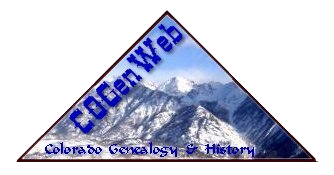
Ranches bought for Granby Reservoir (Lake Granby). Grand Lake Area Historical Society map. Names you know maybe listed. e.g., Sam S. Sigman-Sigman Meat Company. Eslick & Thompson. Eslick & Thompson property now Cutthroat Bay, SW1/4 Section 26 Township 3N R76 W 160 acres. The Harvey ranch was also one hence Harvey Island in Lake Granby.
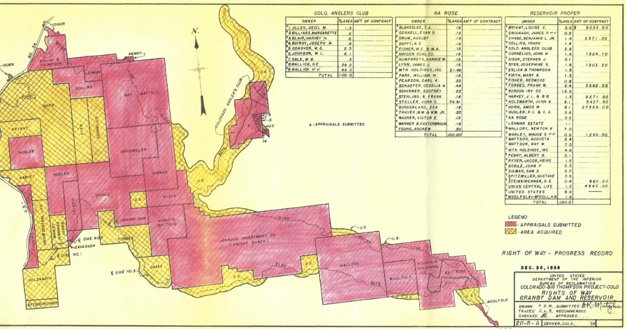
Picture of the Harvey Ranch before the reservoir was built
If you have questions, contributions, or problems with this site, email:
Coordinator - Rebecca Maloney
State Coordinator: Colleen Pustola
Asst. State Coordinators: Rebecca Maloney - Betty Baker - M.D. Monk
If you have questions or problems with this site, email the County Coordinator. Please to not ask for specfic research on your family. I am unable to do your personal research.