
Phillips County Colorado

Plat Maps and Land Owners
List of land Owners by last name
This list was first published in 1911
Range - Township Map
Map Notes:
Land survey townships are six miles square and are sub-divided into thirty-six sections. Township numbers are referenced to the survey grid "Baseline" at 40° North running east to west through Yuma County. Range numbers are referenced to the 6th Principal Meridian which runs north to south in Eastern Nebraska.
Townships in Range 42 West along the eastern edge of Phillips County are shared with Chase and Perkins Counties in Nebraska. Townships in Township 9 North are split evenly between Phillips and Sedgwick Counties.
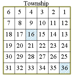
The 36, one mile square, sections in each township are numbered from the northeastern corner of the township as shown in the map below..
Sections 16 and 36 are colored to indicate the owner was originally the State of Colorado while the rest of the sections in the township were retained by the U.S. government and sold under the 1862 Homestead Act and under other acts to individuals.
Township locations within Phillips County are shown on the map
Further information about each patent may be obtained by visiting the BLM GLO Records database
- http://www.glorecords.blm.gov/
Copies of the Land Office files for any of these patents can be obtained from the National Archives.
If you have questions, contributions, or problems with this site, email:
Coordinator - Rebecca Maloney
State Coordinator: Rebecca Maloney
Asst. State Coordinators: Betty Baker
If you have questions or problems with this site, email the County Coordinator. Please do not ask for specfic research on your family. I am unable to do your personal research. I do not have access to additional records.