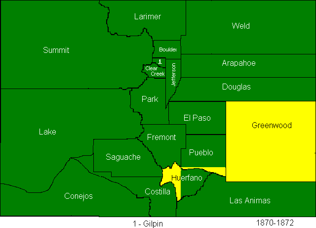
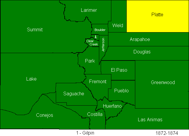
The creation of Greenwood county to finally cover the Cheyenne Reservation
also brought with it several other changes. Greenwood took part of Huerfano
county, and Pueblo also took a bit of Huerfano county. Huerfano county took the
southern half of Fremont county as a consolation for losing so much of the
eastern part of the state.
Bent County was created, but its boundaries are
not shown on the map.
August 20, 1870
“ At a mass meeting of the democracy
of Bent county, held at the court house in Las Animas City, on Saturday, August
13th, Wm. B. Jack was chosen chairman and Robert K. Vandiver, secretary. The
following nominations were made; R. K. Vandiver, county clerk; R. M. McMurray,
county commissioner for district number one; Joseph Graham, county commissioner
district number two; and Riely Higby, county commissioner for district number
three; John W. Pravens, treasurer; John Moiling, sheriff; Charles L. Rite,
probate judge; Moses. R. Tate, Assessor; George Bicknell, coroner. The following
county committee was chosen, L. Craig, R. K. Vandiver, Jesse Nelson, Charles L.
Rile, and Joseph Graham. “
“At a republican county convention held at
Kit Carson, county seat of Greenwood county, Colorado territory, on the 2d of
July, 1870, Theron W. Johnson was chosen president and M. F. Stiles secretary.
The following gentlemen were chosen to cast the vole of the county in the
territorial convention: Louden Mullen, J. F. Buttles and E. F. Jones, (if so
many delegates are allowed) but if only one is allowed Louden Mullen to cast the
vote of said county, with full power of substitution.”
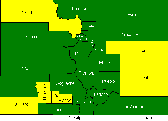
In 1874, Greenwood and Platte Counties were abolished, La Plata, Hinsdale,
Rio Grande, Elbert, and Grand Counties were created, Greenwood’s area was
divided between Bent and Elbert.
February 7, 1874
A few days
ago the legislature passed a bill dividing Douglas county, erecting from one
portion of it the county of Elbert. This necessitated the appointment of county
officers by the governor, it being some months before the regular election will
take place. The governor has therefore selected the following named gentlemen to
serve as county commissioners: Joseph F. Grogan, Henry Wendling and George Aux.
Mr. Bonnifield, who was a commissioner in Douglas county, being now in Elbert
county, retires from the Douglas county board, and Mr. P. Van Wormer is
appointed to the vacancy. The following are remaining officers of Elbert county:
Treasurer, A. L. Gleason; sheriff, Alexander Barron ; clerk and recorder, E. P.
Clark; assessor, D. C. Maxon ; superintendent of public schools, Frank F.
Willard; coroner, John Mather.
February 13, 1874
“Enlargement of
Bent County. The bill dividing Greenwood county, annexing the Southern portion
to Bent, and the northern to the new county of Elbert, has become a law. The
north line of Bent County is as follows : Commencing on the Eastern boundary
line of Colorado at its intersection with township line between townships 13 and
14 , thence west on said township line to the range line between ranges 59 and
60 . The bill provides that all property belonging to Greenwood county shall
hereafter ‘ belong to Bent county . The County Commissioners of Bent and Elbert
counties have power to adjust, settle, and equitably divide all matters of
revenue and indebtedness which may be necessary to adjust and settle on account
of the abolishing of Greenwood county. By this change Bent county gets about one
hundred additional miles of railroad, besides settlements up Sand Creek, Horse
Creek and on Steel’s Fork. The taxable wealth of Bent will be more than doubled
by this addition. As far as we can learn, the change is entirely agreeable to
the inhabitants of Greenwood .